Burnett diversion fish passage
|
Location
Client |
Mackay, Idaho
Trout Unlimited |
The Burnett diversion is located near Mackay, Idaho on the Big Lost River. The existing diversion is a concrete sill structure approximately 10 feet wide and 80 feet long, and was constructed in the early 1900’s. The structure facilitates the diversion of a maximum of 172 cfs for irrigation.
When the structure was built, the river was straightened through the project reach to simplify construction and facilitate water deliveries. This decreased channel length and increased channel slope and water velocity, leading to significant channel down-cutting below the structure. By 2009, the channel bed below the structure had down cut approximately six feet. This exposure was endangering the integrity of the structure, presented a public safety hazard, and blocking all upstream fish passage.
The Big Lost River contains an isolated population of mountain whitefish which has experienced significant declines in numbers throughout their historic range within the basin. The concern over the potential listing of the whitefish as an endangered species combined with the stability concerns related to the diversion brought the Big Lost Irrigation District together with Trout Unlimited and the Natural Resources Conservation Service to develop a project to meet both irrigation and fisheries objectives. Based on that collaboration, a rock ramp was identified as being the preferred project alternative that would best meet the needs of the stakeholders and stay within budget constraints by maintaining the existing concrete diversion.
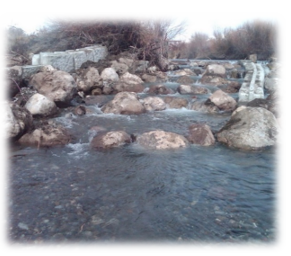
The project design utilizes a rock ramp to improve the stability of the existing structure and to provide upstream whitefish passage. The rock ramp is approximately 50 feet long at a slope of 12 percent, containing a mixture of 36-inch plus granite boulders and native channel substrate. The ramp configuration and hydraulics were targeted to facilitate the swimming characteristics of whitefish, which have a limited jumping ability.
When the structure was built, the river was straightened through the project reach to simplify construction and facilitate water deliveries. This decreased channel length and increased channel slope and water velocity, leading to significant channel down-cutting below the structure. By 2009, the channel bed below the structure had down cut approximately six feet. This exposure was endangering the integrity of the structure, presented a public safety hazard, and blocking all upstream fish passage.
The Big Lost River contains an isolated population of mountain whitefish which has experienced significant declines in numbers throughout their historic range within the basin. The concern over the potential listing of the whitefish as an endangered species combined with the stability concerns related to the diversion brought the Big Lost Irrigation District together with Trout Unlimited and the Natural Resources Conservation Service to develop a project to meet both irrigation and fisheries objectives. Based on that collaboration, a rock ramp was identified as being the preferred project alternative that would best meet the needs of the stakeholders and stay within budget constraints by maintaining the existing concrete diversion.
The project design utilizes a rock ramp to improve the stability of the existing structure and to provide upstream whitefish passage. The rock ramp is approximately 50 feet long at a slope of 12 percent, containing a mixture of 36-inch plus granite boulders and native channel substrate. The ramp configuration and hydraulics were targeted to facilitate the swimming characteristics of whitefish, which have a limited jumping ability.
