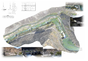
Idaho power upper malad power plant survey
|
Location
Client Date Cost |
Gooding County, Idaho
Idaho Power 2015 $11,000 |
QCI provided a topographic/bathymetric and facilities survey for use by CH2M in their design of a new fish passage facility through the existing Malad Diversion Dam. QCI completed a topographic/bathymetric survey of existing diversion dam and intake flume and approximately 1,200 feet of river channel. QCI utilized terrestrial and aerial based photogrammetry to safely map the steep canyon walls and other difficult to access areas of the site, and combined that work with traditional total station and GPS surveying to provide the final base map.
